IARPA Selects Kitware for Final Phase of SMART Program to Advance Geospatial Analytics Technology
Kitware will refine GeoWATCH, its open source software toolkit for analyzing satellite imagery, to be used in operations by government and commercial organizations
Clifton Park, N.Y. (April 25, 2024) – Kitware, a leader in artificial intelligence (AI) and computer vision, has been awarded a contract by the Intelligence Advanced Research Projects Activity (IARPA) to participate in the third and final phase of the Space-based Machine Automated Recognition Technique (SMART) program. Since the SMART program first began in 2020, the aim has been to develop solutions that can detect and monitor man-made activity across the globe using satellite imagery. After four years and two phases, this third and final phase will focus on transitioning the geospatial analytics technology to government and commercial users. Kitware is leading a team that includes DZYNE Technologies, LLC, Washington University in St. Louis, Rutgers University, and the University of Connecticut.
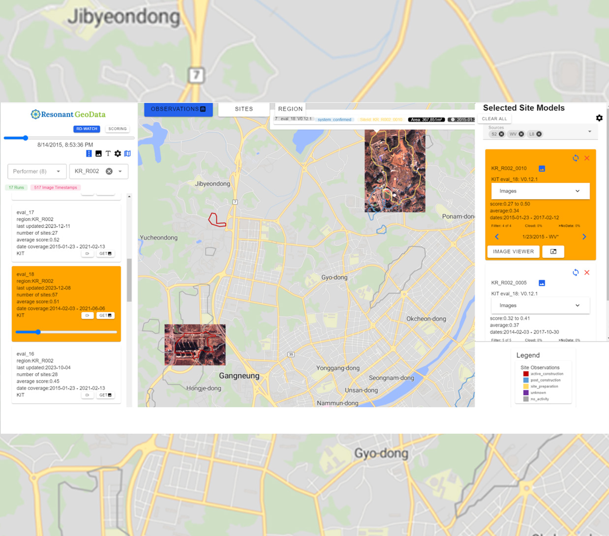
“This is a competitive program and we are excited that Kitware was selected to continue,” said Matt Leotta, Ph.D., assistant director of computer vision at Kitware and principal investigator for Kitware’s SMART team. “We are looking forward to maturing our AI technology, GeoWATCH, by leveraging the latest advances in computer vision and AI to train vision transformer models. Our approach is highly flexible and adapts to variability of resolution, spectral response, and revisit rates of various satellite platforms. We are also leveraging our expertise in data visualization to develop a web-based user interface that will make the algorithms accessible to users who don’t have a background in machine learning.”
GeoWATCH is Kitware’s open source software toolkit that contains all of its R&D work under the IARPA SMART program. Kitware is the only SMART performer to make all of its work freely available to the government and the general public. Under this new contract, Kitware will continue to develop GeoWATCH, including expanding the application to new search tasks and allowing users to easily define their own search tasks. The software includes documentation and tutorials to help users get started in adapting the technology for their own uses. Those interested in adopting this technology can access the source code or contact Kitware for help.
This research is based upon work supported in part by the Office of the Director of National Intelligence (ODNI), Intelligence Advanced Research Projects Activity (IARPA), via 2021-201100005. The views and conclusions contained herein are those of the authors and should not be interpreted as necessarily representing the official policies, either expressed or implied, of ODNI, IARPA, or the U.S. Government. The U.S. Government is authorized to reproduce and distribute reprints for governmental purposes notwithstanding any copyright annotation therein.
About Kitware
Kitware delivers innovation to its customers. As a software research and development company, Kitware solves the world’s most complex scientific challenges using custom software solutions built on open source technology. In addition to custom software development, the company also offers technical support and training services to anyone using its open source tools. Since its founding in 1998, Kitware has developed a reputation for its unparalleled technical expertise and excellent customer service. The company is proud to be 100% employee-owned. For additional information, visit kitware.com or follow them on Twitter, LinkedIn, and Facebook.
About DZYNE
DZYNE is a high-growth, leading technology developer and manufacturer of Group I-V UAS platforms. The Company’s platforms provide advanced intelligence, reconnaissance, and surveillance capabilities and the Company specializes in the rapid design, development, and deployment of advanced manned and unmanned systems. DZYNE integrates artificial intelligence into its operational aircraft with state-of-art payloads and end effects through concept creation, rapid prototypes, and finished products and can provide its aircraft with advanced full-motion video and video processing, autonomous navigation, and targeting and tracking capabilities. Visit us at www.dzynetech.com/.