3D Reconstruction, Point Clouds, and Odometry
From satellite imagery to lidar scans, 3D data unlocks a new dimension of understanding. Kitware transforms raw imagery and sensor data into rich, precise, and actionable 3D models, including meshes, point clouds, NeRFs, and Gaussian splats, empowering customers to map, measure, and navigate complex environments with unmatched clarity. Our open-source software and AI-enhanced algorithms deliver scalable solutions for geospatial intelligence, industrial inspection, autonomous systems, and more.
Government Applications
AI-Enhanced 3D Intelligence for Mission Success
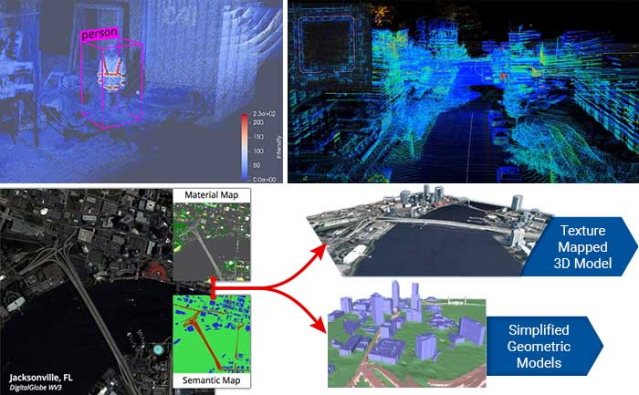
For more than a decade, Kitware has partnered with the U.S. Department of Defense to advance photogrammetry and 3D reconstruction technology. Our TeleSculptor software, originally developed for geospatial 3D reconstruction from full-motion video (FMV), is now an open source application used across domains, including Wide Area Motion Imagery (WAMI) and satellite video. In addition, our Danesfield platform, created under the IARPA CORE3D program, delivers state-of-the-art 3D reconstruction and semantic segmentation from multiview satellite imagery.
Key Benefits
- Precision reconstruction from multiple modalities: Create accurate 3D models from full-motion video (FMV), Wide Area Motion Imagery (WAMI), and satellite data to enhance situational awareness.
- Comprehensive metadata support: Decode, encode, and correct KLV metadata in compliance with MISB standards to ensure interoperability with ISR workflows.
- Optimize for long lenses: Military imaging systems often use very long focal length (narrow field of view) cameras that challenge conventional photogrammetry software. Kitware’s algorithms are specifically tuned to handle these difficult imaging geometries with precision and stability.
- Semantic 3D reasoning: We make your 3D data more meaningful with cutting-edge workflows that integrate Vision-Language Models (VLMs). VLMs automatically segment and label 3D models into semantically rich categories—such as buildings, roads, trees, vehicles, and water—based on natural language prompts.
- Adaptable to mission constraints: Deploy across cloud, on-premise, or tactical-edge systems to support rapid analysis in bandwidth-limited or disconnected environments.
Commercial Applications
Transforming Imagery into Actionable Insight
Kitware delivers powerful 3D solutions that drive innovation across commercial industries. From drones to ground-based sensors, we help organizations transform imagery and lidar data into actionable insights.
Key Benefits
- AI quality assessment: Integrate AI-driven defect detection and deviation analysis to identify issues early in manufacturing, construction, or infrastructure inspection.
- Flexible visualization and analysis: Our open source LidarView platform supports interactive visualization, object detection, segmentation, and measurement of 3D point cloud data.
- Accurate 3D modeling from any source: High-quality point clouds and surface meshes from imagery or lidar collected by drones, vehicles, or fixed sensors—enabling precise measurements and modeling of complex environments. Applications include infrastructure inspection, environmental monitoring, autonomous driving, and urban planning.
- Custom and flexible solutions: Off-the-shelf 3D tools are often costly and rigid. Kitware delivers custom, scalable solutions tailored precisely to your unique needs. Our software is based on permissively licensed open source platforms, which eliminates expensive licensing fees and enables unlimited users and cloud deployment.
Turn your imagery and sensor data into rich, actionable 3D insight with Kitware’s advanced AI-powered reconstruction and visualization solutions.