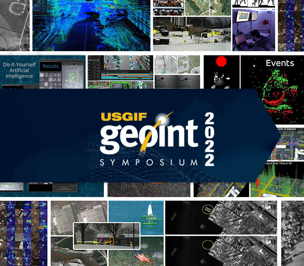
THE GEOSPATIAL INTELLIGENCE SYMPOSIUM (GEOINT)
Hosted by USGIF
April 24-27, 2022 at the Gaylord Rockies Resort & Convention Center in Aurora, Colorado
The GEOINT Symposium is one of the largest gatherings of geospatial intelligence professionals in the U.S., with attendees from government, industry, and academia. Kitware has been participating extensively at GEOINT for several years now and is a highly involved member of the geospatial intelligence community. We work closely with the intelligence community and government defense agencies on geospatial intelligence R&D projects that require experts in AI, machine learning, and computer vision. We are excited to meet with attendees at our exhibitor booth (#1412) to discuss collaboration opportunities. If you would like to schedule time with us during the conference or set up a meeting for a later date, please email our team at computervision@kitware.com.
Kitware’s Activities and Involvement
In addition to being an exhibitor this year, Kitware is pleased to present two training sessions and three lightning talks at GEOINT 2022. You can find the details about these presentations listed below.
Towards Ethical AI and Trusted Autonomy: Legal, Moral, and Ethical Considerations from the DARPA URSA Program
Monday, April 25 from 3-3:05 PM | Lightning Talk
Presenter: Anthony Hoogs, Ph.D., Vice President of Artificial Intelligence at Kitware
Kitware values the need to understand the ethical concerns, impacts, and risks of using AI. Urban Reconnaissance through Supervised Autonomy (URSA) is a DARPA program with the goal of developing autonomous systems that work with humans to provide actionable intelligence in complex urban environments. URSA involves interactions with non-combatant civilians, and is exploring legal, moral, and ethical (LME) considerations of operating autonomous systems in gray zone scenarios. URSA has formulated the concept of DevEthicalOps (Ethical Development and Operations), or incorporating ethical considerations into all aspects of system design, development, execution, and data management. This talk will present two LME-specific features that we have implemented in the URSA system to prevent the collection of sensitive information and harm of sensitive areas (e.g. places of worship). These LME additions have improved the performance of the baseline system, suggesting that ethical constraints may provide important benefits in addition to assuring the ethical and trusted use of the system.
Disinformation in the GEOINT Domain: Threats, Challenges, and Defenses
Tuesday, April 26 from 2-3 PM | Training Session
Presenter: Arslan Basharat, Ph.D., Assistant Director of Computer Vision at Kitware
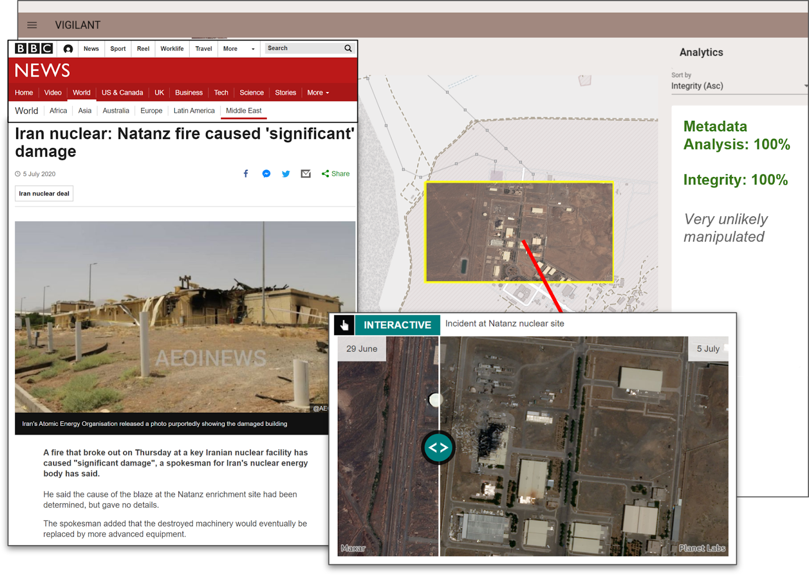
As media generation and manipulation technologies are advancing rapidly, Federal R&D programs such as DARPA MediFor and SemaFor have been instrumental in advancing forensic defenses that incorporate artificial intelligence, machine learning, computer vision, and natural language processing. This training session will describe and illustrate the prevalent threats posed by state-of-the-art automated media generation and manipulation technologies, and demonstrate the common challenges faced by ML approaches for detecting and analyzing such artifacts. Arslan will discuss how multimodal and semantic analytics can address these challenges through state-of-the-art approaches for detecting, attributing, and characterizing disinformation that involves image and text modalities, through case studies in news articles. The training session will also introduce the image forensics capabilities in the VIGILANT satellite imagery exploitation tool (developed by Kitware with funding from AFRL and NGA), which allows a GEOINT analyst to detect, localize, and analyze pixel manipulations in satellite images of questionable authenticity. [Sign up for this training session]
Novelty Detection to Discover Salient Unknown Unknowns
Tuesday, April 26 from 3:30-3:35 PM | Lightning Talk
Presenter: Anthony Hoogs, Ph.D., Vice President of Artificial Intelligence at Kitware
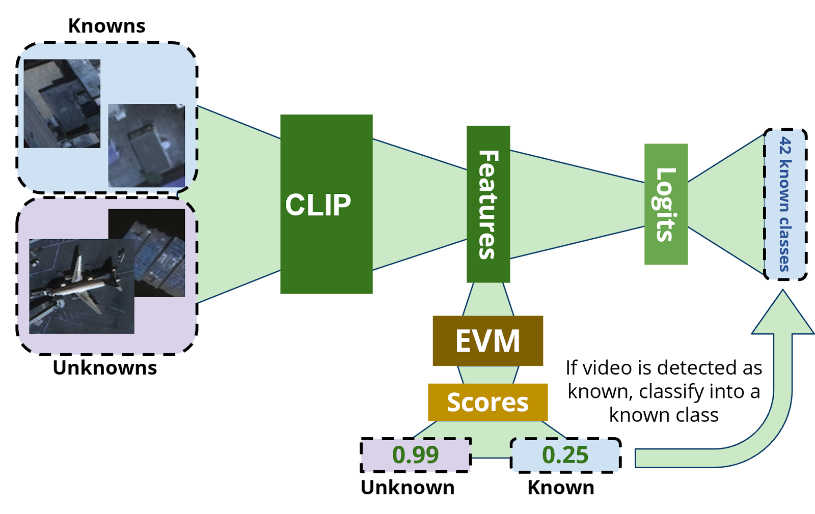
As a result of deep learning approaches, revolutionary advances have been achieved in object detection and classification in satellite imagery. Traditional approaches follow the standard target recognition paradigm by assuming a fixed set of known object classes (e.g. types of airplanes), but these methods can miss important targets that are not sufficiently similar to known classes. In this talk, Anthony will cover novelty detection, which is an emerging technique to explicitly detect unknown objects while continuing to classify instances of known object types correctly. Kitware has developed a method that uses extreme value theory and has conducted experiments on the xView dataset. Our results indicate that our approach is more effective at finding novel objects, even when novel classes are similar to known ones than the baseline approach of thresholding on classification probabilities of known classes. This work is a collaboration with the University of Colorado and Notre Dame.
Explainable AI for Imagery Analysis
Wednesday, April 27 from 7:30 AM – 8:30 AM | Training Session
Presenter: Anthony Hoogs, Ph.D., Vice President of Artificial Intelligence at Kitware
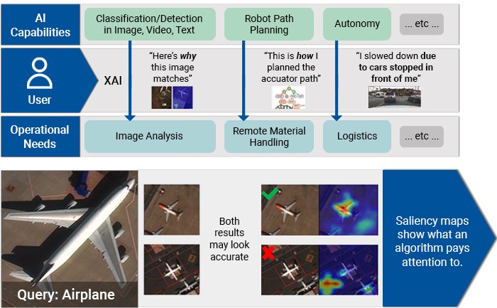
It is important for analysts to have a sense of how data and metadata conditions affect a model’s performance to develop a justified, calibrated sense of trust in the AI model. In this training session, you will learn how contemporary deep learning networks are used in object detection and image retrieval algorithms and how techniques for Explainable Artificial Intelligence (XAI) can help analysts develop a sense of not just “what result did the AI compute?” but “why did the AI compute that result?” Anthony will explain how the developing field of XAI applies to typical image analysis workflows, focusing on object detection and image retrieval as case studies. He will also review the latest in XAI, emphasizing how visual saliency maps can illuminate the behavior of deep learning models, and demonstrating how analysts can use XAI to understand when and why deep-learning models do (and don’t) perform as expected. [Sign up for this training session]
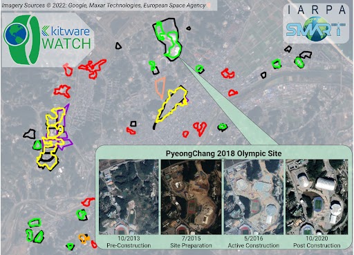
Kitware Results on Phase 1 of the IARPA Smart Program
Wednesday, April 27 from 12:20-12:25 PM | Lightning Talk
Presenter: Matt Leotta, Ph.D., Assistant Director of Computer Vision at Kitware
The IARPA SMART program brings together many government agencies, companies, and universities to research new methods and build a system to search through enormous catalogs of satellite images from various sources to find and characterize relevant change events as they evolve. Kitware is leading one of the performer teams on this program, including DZYNE Technologies, BeamIO, Inc., Rutgers University, the University of Kentucky, the University of Maryland at College Park, and the University of Connecticut. At GEOINT 2021, Kitware summarized our preliminary results on this program and introduced our system called WATCH (Wide Area Terrestrial Change Hypercube). This year, we will summarize our new progress during the first eighteen-month phase of the program and show improvements in detecting new construction and classifying construction phases. We will also highlight our research results, system integration/deployment progress, and developed open source tools which are already available free for community use.
Physical Event
Gaylord Rockies Resort & Convention Center
Gaylord Rockies Resort & Convention Center
6700 N Gaylord Rockies Blvd
Aurora, CO
Virtual Location